What can we learn from California's devastating wildfires?
As this week’s devastating fires in California have shown, there are extreme dangers to building houses adjacent to forests whose ecological cycles include wildfire. As more and more homes are built in the Wildland Urban Interface (WUI) (California’s WUI zone grew 20 percent from 1990 to 2010), the risk of tragedy in communities across the west grows.

At least 42 people have died in the Northern California wildfire that burned through the town of Paradise with shocking speed. The fire has destroyed more than 6,500 homes and 260 commercial buildings. Find out how you can help.
Noah Berger/AP
"Climate change contributes to the growing destruction from California wildfires. Hot, dry weather conditions that help carry fires for thousands of acres are often present nearly year-round now. The state’s urban sprawl and encroachment into formerly undeveloped land is the real catalyst, though, said former Sacramento Metropolitan Fire District chief Kurt Henke." - California wildfires start in the woods. Why do cities keep burning?
Bend is vulnerable to wildfire too

Longtime Central Oregon residents will remember the Awbrey Hall fire, which ripped through the forested areas west of Bend and burned 16 houses in three hours in 1990. The fire started in early August on a ridge in Shevlin Park, crossed major roads and the Deschutes River to travel 6 miles and destroy a total of 22 homes in its wake.
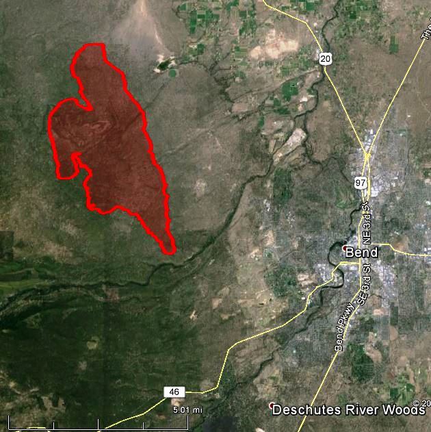
More recently, the Two Bulls Fire burned 6,908 acres west of Bend, causing the evacuation of about 254 homes and around 635 people on the west side of Bend in June, 2014. It came within three miles of the city and thankfully avoided catastrophic destruction due to favorable winds.
“A recent Villanova University study found there are about 7 million homes in fire-prone areas in the West, more than 10 times the 600,000 or so that were present in 1940. Environmental scientists believe 1.2 million more could be built in the highest-risk areas throughout California between 2000 and 2050.”
As development pressures grow in high-risk areas, we must consider every new development in the WUI carefully. Smart planning that takes wildfire risk into account will help avoid unnecessary loss of life and homes, risk to our health, and endangerment of firefighters. That is why we are on the front lines in defense of sensible land use planning.
Please consider helping our neighbors to the south: suggestions from The Source.