Protect Deschutes County farmland: 710 acres in the Lower Bridge Valley

View of the northeastern edge of the property in question, overlooking neighboring farm and rangeland: Central Oregon LandWatch
Protect Deschutes County farmland
Ask the County to stand with farmers and ranchers

Aerial view of the 710-acre area, from the Notice of Appeal
Next week, the Deschutes County Board of County Commissioners will decide the fate of 710 acres in the Lower Bridge Valley near Terrebonne. On August 17, the Deschutes County Board of County Commissioners (BOCC) will review a request to convert 710 acres away from agricultural land to allow for rural residential development. Whether they approve or deny the proposal will impact the Lower Bridge farming community for decades to come.
During the initial hearing in April, LandWatch testified in opposition to this proposal. Over 150 people submitted testimony and many spoke out during the hearing, in defense of this area as agricultural land. We took a stand alongside neighboring farmers and ranchers to protect this area for farm use.
Now, we are asking the Deschutes County Commission to do the same.
Our choices today determine Central Oregon’s farming future
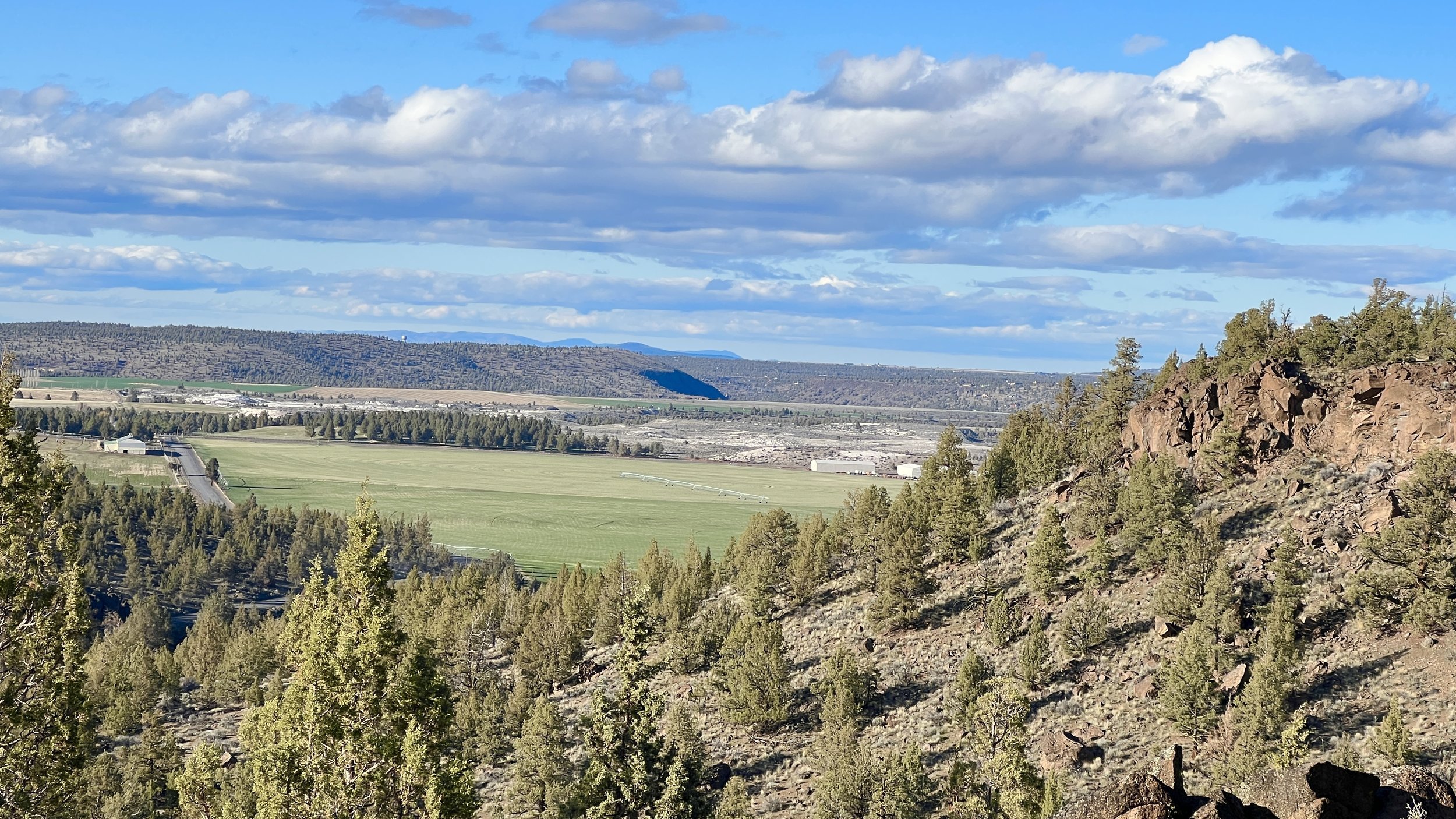
View of the southeastern edge of the property overlooking neighboring farm and rangeland: Central Oregon LandWatch
In the Lower Bridge Valley, farms and ranches produce a wide array of local food and products, from award-winning wines to locally-sourced beef to fresh flowers and produce. Here, you can witness the vast, open landscapes separated only by the rolling hillsides that set this peaceful farming community apart.
We can't stand to lose this agricultural valley to sprawling development.
This area is protected for exclusive farm use, meaning that Deschutes County identified this area as part of the limited supply of Oregon’s remaining agricultural land. Oregon’s land use laws are designed to protect agricultural land, to keep it intact with limited allowances for residential development that isn’t in line with farming needs.
This zone change would remove farmland protections across hundreds of acres, permanently shifting the use away from agriculture to allow for rural residential development.
There is also a parallel concern over groundwater use and drying wells in this area. If this application were approved, this area could see up to 71 new wells tapping into the aquifer, largely without regulation or oversight on the amount of water.
The Oregon Department of Agriculture, the Oregon Department of Fish and Wildlife, and the Oregon Department of Land Conservation and Development took the unusual step of opposing this proposal in a joint, three-agency letter explaining in detail why converting the land in this rural farming community to a subdivision is against the law.

Neighboring ranching land: Central Oregon LandWatch
A number of neighboring farmers and ranchers have also expressed concern. From worry over water use and added stressors to the farming community to the disruption of important wildlife habitat, the application has drawn widespread criticism.
Help us take action and ask the Deschutes County Board of County Commissioners to consider the future of the Lower Bridge Valley and deny the proposal.
You can find more details about this application from Deschutes County’s Proposal Summary.
Take action
The public has been asked to weigh in before and during the hearing next Wednesday, August 17, at 2:00 p.m. Here are a few ways to participate.
Attend the hearing on Wednesday, August 17 at 2:00 p.m. or 5:30 p.m.
This virtual hearing is open to all individuals (registration not required) and will be held on Zoom and in-person at the Barnes and Sawyer Room, 1300 NW Wall Street in Bend. The meeting will begin at 2:00 p.m. with a scheduled afternoon recess, to resume again at 5:30 p.m.
Anyone can speak and provide oral testimony at the hearing. If you plan to speak, the County requests you email Haleigh King at haleigh.king@deschutes.org by 4:00 p.m. Tuesday, August 16. Each person will be given 3 minutes to speak.
Send in a written comment
You can submit a comment to the public record by emailing Haleigh King, Associate Planner, at haleigh.king@deschutes.org. Make sure to include the land use file numbers: 247-21-001043-PA, 1044-ZC.
Talking Points
Interested in ideas for what to say or write? Here are some issues to consider:
Agricultural land use and a farming future
If this application is approved, these 710 acres will permanently lose farmland protections. The land will be converted away from agricultural use to allow for remote and sprawling rural residential development, fracturing an intact landscape. The applicant claims that this land hasn’t been historically farmed, but that is not what Oregon’s land use laws were meant to determine. They were designed to protect a farming future and the availability of agricultural land, not reflect the choices of a particular landowner. With Central Oregon losing farmland at an alarming rate, we must protect the intact agricultural landscapes that remain.
Neighboring farms and ranches
This property is surrounded by working farms and ranches in Deschutes County. Unplanned rural sprawl brings additional stressors to farming communities. For example, increased impact to infrastructure (i.e. traffic on country roads, complaints from noise and dust related to farm operations) makes it more difficult for farmers and ranchers to continue their work. What’s more, we’ve heard that neighboring ranchers could be interested in the land for future ranching operations. Learn more from this short video.
Unpermitted wells
There is growing concern over groundwater use and drying wells in this area. If this application were approved, this area could see up to 71 new wells tapping into the aquifer, largely without regulation or oversight on the amount of water. The concern over unregulated groundwater and well use is why housing is typically more condensed and directed in cities and towns, to prevent dewatering a large landscape reliant on unpermitted groundwater wells.
Wildlife habitat and mule deer migration
This area is vital winter range for local mule deer herds. The Metolius herd is declining by 10% every year and rural development in the winter range is the primary cause. The latest wildlife studies show this property as an essential seasonal migration corridor that should remain intact and with minimal disturbance for healthy wildlife populations. The Oregon Department of Fish & Wildlife has informed Deschutes County that this property is biological mule deer winter range. Approving this application and allowing for the sprawling development of up to 71 houses would fracture this vital habitat range.
Urban use of rural land
If this application is approved, the addition of 71 or more new residential dwellings in this area would bring an urban level of development to this rural landscape. With urban levels of development come increased needs and impacts to infrastructure, including traffic management, water, sewer systems, and more. Additionally, public services like schools, public safety, and fire needed to serve this level of development belong in cities. Expanding urban development into rural farming communities is a huge barrier to successful farming and ranching economies.
Widespread opposition
During the initial hearing in April, every person who testified spoke in opposition to the development. Over 150 written comments were submitted in opposition. Additionally, the Oregon Department of Agriculture, the Oregon Department of Fish and Wildlife, and the Oregon Department of Land Conservation and Development took the unusual step of opposing this proposal in a joint, three-agency letter explaining in detail why converting the land in this rural farming community to a subdivision is against the law. This is a matter of widespread opposition and great public concern. The public interest will not be best served by rezoning the property. The loss of agricultural land, impacts to neighboring farms and ranches, loss of mule deer habitat, increased traffic and strain on public services, injury to groundwater resources, and wildfire risk posed by this development will not serve the public health, safety, and welfare.
Wildfire risk
With increasing wildfire safety risks to homes and structures in Central Oregon, this particular area is an unsafe and unwise place for residential development. According to Oregon’s recently released wildfire risk maps, part of this area is designated as a high fire-risk area. In planning for a safe future, this is not a wise place for residential development or expanding development into the wildland-urban interface.

McKayla Crump
Help share the word
Do you know someone who may be interested in this issue? Please share this webpage with any individuals, groups, or organizations that come to mind. If you’d like to stay up-to-date on this issue and other related concerns for Central Oregon, sign up for our email list.